
Product
-
Weather station
-
Road Weather Station
-
Photovoltaic Inspection
-
Atmospheric monitoring
-
Operating condition monitoring
Recommended article
- The price of meteorological monitoring systems varies from 3,900 to 39,800 yuan depending on the number of monitored elements
- Power Quality Measurement Makes Power Grid Harmonic Detection and Data Logging More Efficient
- High-Precision Meteorological observation equipment Aids Field Environmental Monitoring
- How Forest Weather Station Improves Forest Fire Risk Early Warning Capabilities Through Real-Time Data Acquisition
- The Electrical Power Analyzer's four-channel synchronous measurement capability enhances the efficiency of photovoltaic grid-connected testing
- How Ultrasonic Snow Depth Monitoring Stations Achieve Accurate Snow Depth Measurement
Contact us
Shandong Fengtu IOT Technology Co., Ltd
Sales Manager:Ms. Emily Wang
Cel,Whatsapp,Wechat:+86 15898932201
Email:info@fengtutec.com
Add:No. 155 Optoelectronic Industry Accelerator, Gaoxin District, Weifang, Shandong, China
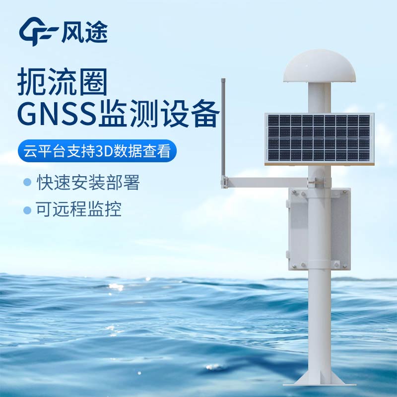
GNSS Monitoring Stations for Reservoir Subsidence: High-Precision, All-Weather Solutions
Article source:Weather station time:2025-06-06 09:19:55 viewed:461times
Global Navigation Satellite Systems (GNSS), with their advantages of high precision, all-weather operation, and automation, have become a critical technical means for reservoir subsidence monitoring.
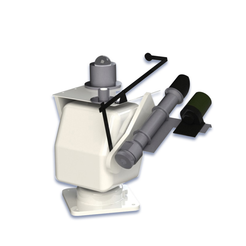
A GNSS monitoring station is primarily composed of two major components: hardware equipment and software systems. Among the hardware devices, the core GNSS receiver can simultaneously receive satellite signals from multiple systems, including GPS, GLONASS, Galileo, and BeiDou. Equipped with a high-precision clock and multi-channel signal processing modules, it ensures stable reception and parsing of signals. The antenna part must have strong anti-interference and multipath suppression capabilities, typically using choke ring antennas to effectively reduce errors caused by signal reflections. Additionally, the antenna must be installed on a sturdy tripod or observation pier to ensure it remains stable and does not shift.
Data transmission equipment includes wireless transmission modules (such as 4G, 5G, and BeiDou short message service) and wired transmission devices (fiber optics, Ethernet), enabling real-time data transmission back to the control center.
A GNSS monitoring station calculates the three-dimensional coordinates of the monitoring station with high precision by receiving signals from multiple satellites and using the principle of distance intersection between satellites and the receiver. In reservoir subsidence monitoring, subsidence information in the reservoir area is obtained by continuously collecting coordinate data of the monitoring station over the long term and comparing coordinate changes across different periods.
In practical applications, GNSS monitoring stations must first be rationally deployed on the reservoir dam and surrounding areas. The reference station should be located in a geologically stable area far from the influence of the reservoir to provide a high-precision reference for the entire monitoring network. Monitoring stations are evenly distributed at key positions on the dam and in potential subsidence areas. Receivers at each monitoring station receive satellite signals in real time and transmit the data to the data processing center. During data processing, professional software is used to solve and calculate the original observation data, eliminating errors caused by the ionosphere, troposphere, and other factors. Differential calculations are performed in combination with reference station data to obtain three-dimensional coordinate changes of the monitoring stations at the millimeter or even sub-millimeter level. The software system is responsible for data collection, storage, analysis, and management, capable of automatically identifying and eliminating abnormal data, as well as generating visual subsidence change curves and reports.
Compared with traditional methods such as leveling, GNSS monitoring stations are not limited by line-of-sight conditions, enabling efficient operations in complex terrain environments. They also enable 24-hour uninterrupted monitoring to timely detect reservoir subsidence. Monitoring data can be automatically collected, transmitted, and analyzed, improving observation efficiency and the timeliness of data processing.
This paper addresses:https://www.fengtuweather.com/industry/718.html
Related products
Related article
-
Fengtu Automated Weather Monitoring for the Modern Farm
2024-08-13 -
Visibility sensor: Unlocking Precision in Atmospheric Visibility Measurement and Beyond
2024-11-25 -
The role of weather stations in the forage industry
2024-02-28 -
PV Module Power Testers Enable Rapid On-Site IV Curve Testing
2026-04-22 -
Police radar gun Precise, Non-Contact Speed Measurement via Radio Waves
2026-03-27 -
Unlocking the Benefits of Fresh Air: Negative Oxygen Ion Monitoring Systems in Tourism Destinations
2024-09-13 -
Grassland Ecological Monitoring Station - Empowering Sustainable Grazing
2024-12-13 -
Sensors, the sensing equipment of a weather station system
2024-06-14