
Product
-
Weather station
-
Road Weather Station
-
Photovoltaic Inspection
-
Atmospheric monitoring
-
Operating condition monitoring
Recommended article
- The price of meteorological monitoring systems varies from 3,900 to 39,800 yuan depending on the number of monitored elements
- Power Quality Measurement Makes Power Grid Harmonic Detection and Data Logging More Efficient
- High-Precision Meteorological observation equipment Aids Field Environmental Monitoring
- How Forest Weather Station Improves Forest Fire Risk Early Warning Capabilities Through Real-Time Data Acquisition
- The Electrical Power Analyzer's four-channel synchronous measurement capability enhances the efficiency of photovoltaic grid-connected testing
- How Ultrasonic Snow Depth Monitoring Stations Achieve Accurate Snow Depth Measurement
Contact us
Shandong Fengtu IOT Technology Co., Ltd
Sales Manager:Ms. Emily Wang
Cel,Whatsapp,Wechat:+86 15898932201
Email:info@fengtutec.com
Add:No. 155 Optoelectronic Industry Accelerator, Gaoxin District, Weifang, Shandong, China
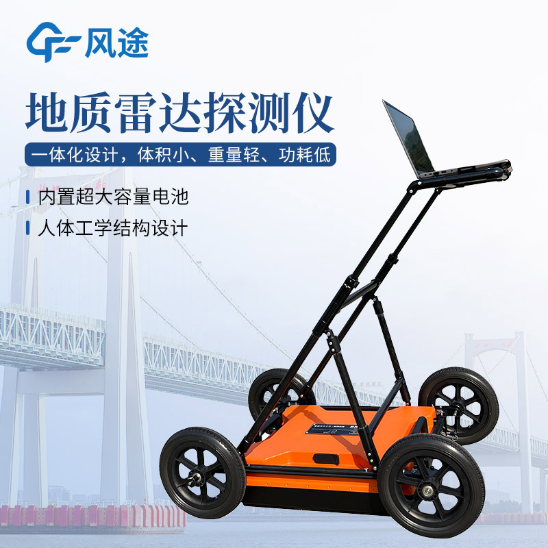
Ground Penetrating Radar: The Core Tool for Advanced Geological Prediction in Underground Engineering
Article source:Weather station time:2025-07-25 09:17:27 viewed:521times
In the field of engineering construction, especially in underground engineering construction such as tunnels, subways, and mineral mining, advanced geological prediction is a key link to ensure construction safety and efficiency. As a core equipment for realizing advanced geological prediction, Ground Penetrating Radar has become an indispensable tool for engineering and technical personnel.
Advanced geological prediction refers to the work of detecting, analyzing and predicting the unexposed geological conditions in front of the construction using professional technical means before or during the project construction. The purpose is to detect possible unfavorable geological bodies in advance, such as fault fracture zones, karst caves, groundwater-rich areas, etc., so as to provide a scientific basis for the optimization of engineering design and the adjustment of construction plans, thereby avoiding the occurrence of geological disasters and reducing engineering risks.
Ground Penetrating Radar realizes geological detection based on the principle of electromagnetic wave propagation. The equipment is mainly composed of a transmitting antenna, a receiving antenna, a host and a data processing system. During operation, the transmitting antenna emits high-frequency electromagnetic waves to the ground. The electromagnetic waves will be reflected and refracted at the interface of different media. The receiving antenna captures the electromagnetic wave signals reflected back to the ground. The host collects and records the signals, and then the data processing system analyzes and processes the original data, and finally generates a profile map reflecting the underground geological structure.
Ground Penetrating Radar is widely used in advanced geological prediction because it has the following advantages: it has a fast detection speed, which can meet the progress requirements of engineering construction; it has high resolution, which can identify small-scale geological anomalies; it is easy to operate, and detection can be carried out only by arranging antennas on the ground or in the constructed section; and it is a non-destructive detection method, which will not damage the engineering structure and the surrounding environment.
In practical engineering applications, the use process of Ground Penetrating Radar is relatively standardized. First, determine the detection scheme according to the engineering characteristics and detection objectives, including parameter settings such as antenna frequency selection and survey line layout. Then, on-site data collection is carried out, and technical personnel need to ensure the stable operation of the instrument and the quality of the data. After the data collection is completed, professional software is used to process and interpret the data, analyze and judge the underground geological conditions in combination with geological data, and finally form an advanced geological prediction report to provide guidance for engineering construction.
This paper addresses:https://www.fengtuweather.com/industry/754.html
Related products
Related article
-
Odor Online Monitoring - A Solution for Malodor Detection
2024-10-24 -
Portable Vehicle-Mount Weather Station: Precision Meteorological Monitoring for On-Road Safety
2025-07-24 -
What is a small automatic weather station device?
2024-05-20 -
Detecting Deep - Buried Non - Metallic Pipelines with Ground Penetrating Radar
2025-03-05 -
Introduction to the Integrated Forest Fire Risk Monitoring Station
2024-04-22 -
How PV Weather Station Optimizes Photovoltaic Power Generation and Management
2024-11-28 -
High-Precision Meteorological observation equipment Aids Field Environmental Monitoring
2026-07-21 -
Road Weather Station monitors weather changes to support smart transportation
2025-11-18